Patricia Falls
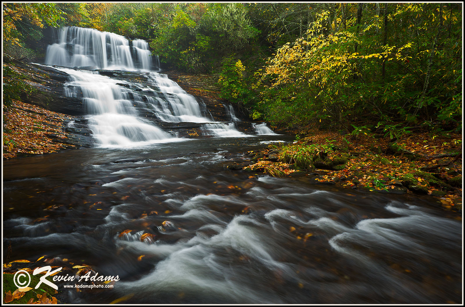
Nikon D700, Nikon 17-35mm lens at 17mm, f/16. 0.6 second, ISO 400, polarizing filter. Shot while raining.
 View waterfall on Google Earth. Link is for a Google Earth file. Click file after download and Google Earth will open and fly to the waterfall. Don't have Google Earth on your computer?
Driving Directions
The trailhead is at Balsam Lake Recreation Area on Charleys Creek Road (SR 1756). From the east, turn off NC 215 onto Charleys Creek Road 3.2 miles south of the Blue Ridge Parkway. Follow Charleys Creek Road 5.3 miles to Balsam Lake. From the west, you can access Charleys Creek Road from NC 281, some 8.4 miles south of NC 107. From that direction, it is 5.4 miles to Balsam Lake.
Hike Description
I’m giving directions here to the four waterfalls that are close together on Wolf Creek: Balsam Falls, Lower Balsam Falls, Patricia Falls, and Lauren Falls. The hike begins at the parking area at Balsam Lake Recreation Area. Mallonee Trail begins across the footbridge over Wolf Creek at the upper end of the lake. Follow the trail a little less than 0.5 mile to the dam.
Along the way you’ll see Balsam Lodge on a ledge above the dam on the far side of the lake. The lodge is open for renting from April 1 to November 1. If you’re a renter, you could also reach the waterfalls from that side, but the access road for the lodge is closed to everyone else, including hikers. During the winter it seems to be in a gray area regarding access, but the Forest Service official I spoke with didn’t even want me to mention that the road existed. Since you’ll know the road is there if you open your eyes, I figured I should mention that you aren’t supposed to hike it. To be honest, you wouldn’t gain much by going that way anyway.
At the dam, a path turns left and follows the creek downstream. It’s not much better than a full bushwhack, but if you pay attention you should be able to follow it okay. It leads less than 0.2 mile to the base of Balsam Falls. The last few feet on the steep rock are a little dicey.
Once you reach the base, you won’t be able to see the falls well without crossing to the other side, and you’ll have to do that to see the other waterfalls. You’ll cross by wading the pool. The brink of Lower Balsam Falls is at the downstream end of the pool, so I hope I don’t have to tell you stay away from it. If you cross several yards away from the brink, you should be okay in normal flows. If the water is up, turn around.
Once across, scramble up the path on the steep rocks. Be careful, this is a good spot to break a leg. Crawl through the rhododendron for a few feet and you’ll come to a switchback in another trail. To the right is the path leading up to the lodge. Go left and in a few yards you’ll see another scramble path on the left that leads down to the base of Lower Balsam Falls.
Continue straight to reach Patricia Falls and Lauren Falls. The path may be hard to follow and covered in rhodos, but just keep following the route of least resistance. If you managed to stay on the path, you’ll soon intersect another path. Turn left and follow that path down to the creek. Once at the creek, head downstream. There is no real trail, but it’s not difficult. Not this part, anyway. After you cross a small branch, you’ll need to cross Wolf Creek. This will likely be a wade during normal flows. The brink of Patricia Falls is just around the bend in the creek, so you’ll want to cross just after you come to the small branch.
Once across Wolf Creek, you need to climb up and over the little ridge. You won’t find a very clear path from this point on, but if you look around you’ll see where people have scrambled down the bank. That route is the shortest and easiest for some, but it’s a good way to break a leg if you’re not comfortable with that sort of scrambling. The safer route is to continue up the ridge and make a very wide swing around to reach the base. You’ll find no trail for that and the bushwhack required is torture. If you’ve made it to this point, it’s probably just as well to scramble down the rock, and if you’re not comfortable doing that, turn around.
Lauren Falls is a short distance downstream from Patricia Falls. Follow the creek down on river left toward the top. You may find a route that others have followed to the base. At my last visit, it was mostly grown over. Regardless of how you get down, if you are among the lucky ones and made it this far without breaking anything, you’ll get one final splendid opportunity on the descent. You’ll probably come out first on a ledge near the base of the falls. Be careful, anything on your body that is still in one piece is in jeopardy here. To reach the actual base requires more crawling through the dense growth.
Even those who don’t mind rock scrambling and wading through dense rhodos and doghobble will find nothing enjoyable about the hike to Patricia Falls and Lauren Falls. The waterfalls are beautiful, but you need to be realistic about the effort required to reach them and don’t hesitate turning back.
Overview
I discovered Patricia Falls many years ago, before I wrote the second edition of North Carolina Waterfalls. However, I didn’t include it in that edition or the current third edition. At the time I found it, I saw no indication that anyone had ever been there. Of course, I knew hunters and loggers would have seen it, and probably fishermen, but there were no paths of any kind, no disturbed moss, no beer cans, no names written on little wooden signs nailed to a tree at the falls. Nothing but pristine beauty.
I decided that this waterfall and Lauren Falls, which is a short distance downstream, would remain secret, at least for a while. Today, many people know about these waterfalls and there are obvious indications of their visits. Some years ago, someone even cut some of the rhododendron that was growing out over the falls, no doubt to provide a clear view for photos. And the banks on the river-left side of both waterfalls have lost a good bit of their soil because of people scrambling on them.
For a number of reasons, I decided it was best not to keep these waterfalls secret any longer and to provide detailed information for visiting them. I hope that if you go you will tread lightly and leave everything as you found it. But before you go, please read the hiking information carefully. These waterfalls have a 10 trail rating for a reason. The hike may be short, but it’ll kick your butt and it could break your leg (or worse) if you aren’t careful.
I named Patricia Falls after my wonderful wife. Back when I found it, I wasn’t naming any newly discovered waterfalls. I didn’t start doing that until the recent explosion of waterfallers who like to name every little drop they find. Now I name them in an attempt to establish “official” nomenclature, to help curb the chaos of having a dozen names floating around for a single waterfall. But even though I had no interest in naming waterfalls back then, this one struck me differently. It was such a beautiful and special waterfall and it seemed appropriate that it should be named for such a beautiful and special person.

The brink of Patricia Falls. Nikon D700, Nikon 17-35mm lens at 17mm, f/22. 2 seconds, ISO 200, polarizing filter. Shot while raining.


The brink of Patricia Falls. Nikon D700, Nikon 17-35mm lens at 17mm, f/22. 3 seconds, ISO 200, polarizing filter. Shot while raining.

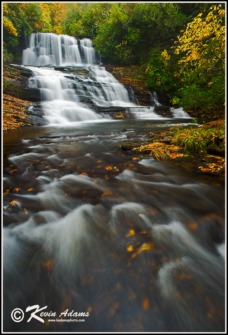
Nikon D700, Nikon 17-35mm lens at 17mm, f/16. 1/5 second, ISO 400, polarizing filter. Shot while raining.
Nikon D700, Nikon 17-35mm lens at 17mm, f/22, 2 seconds, ISO 200, polarizing filter. Shot while raining.